
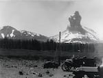
This photograph from 1914, shows volcanic activity on Mount Lassen, in the southern portion of the Cascade Range. The mountain stirred for several months before its largest eruption in May 1915.
Courtesy of the National Park Service
The eruption of Mount St. Helens on May 18, 1980, was a defining moment in the Northwest, but it wasn’t the Cascades’ only volcanic eruption in modern history.
Mount Lassen, in the southern Cascades, erupted on May 22, 1915, 65 years almost to the day before Mount St. Helens.
Also known as Lassen Peak, the mountain is the southernmost active volcano in the Cascade Range. It is located east of Redding, California, about 100 miles south of the Oregon border.
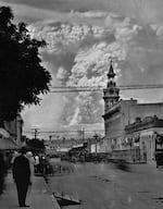
This image dated in 1915 shows the eruption of Mount Lassen as seen from Red Bluff, Calif.
Courtesy of the National Park Service
A volcano captured on film
The mountain unexpectedly started rumbling in May 1914. Over the course of the year, there were nearly 200 steam eruptions, creating a spectacular sight for locals and visitors alike.
Photographers, armed with new, cheaper and more readily available cameras, set out to document the events.
Mount Lassen became one of the first volcanic eruptions ever captured on moving film.
The Shasta Historical Society holds a copy of a short film of the eruption, likely created by a resident of Red Bluff, California — about 30 miles south of Redding — and released in 1918 to promote the newly established Lassen Volcanic National Park.
‘Terror prevails’
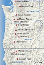
This map, provided by the National Park Service, shows the primary volcanoes in the Cascade Mountain Range.
Courtesy of the National Park Service / Cascade Volcanoes Map
After months of literally blowing off steam, the mountain finally exploded on Saturday afternoon, May 22, 1915.
Lava burst through the mountain’s side, sending a flood of melted snow to the valley below. Meanwhile, a vertical explosion rose more than 30,000 feet, forming a mushroom cloud of gas that could be seen more than 100 miles away.
Incredibly, no one died from the volcanic activity, though The Oregonian reported plenty of damage under a May 23, 1915, article titled “Terror prevails”:
“Farmers were driven from their homes in panic yesterday by the flood of mud that laid a black blanket from one to three feet deep over an area 15 miles long and from one half to two miles wide. They found their crops utterly destroyed, stock killed, and large damage done to farm equipment.”
That eruption proved to be the most powerful, but volcanic activity continued until 1917.
The Cascade Mountain Range spans from British Columbia all the way to Northern California and includes a wide variety of volcano types.
Together, those mountains are part of the Ring of Fire, a string of volcanic arcs that encircle the Pacific Ocean.
According to the U.S. Geological Survey’s website, seven Cascade volcanoes have erupted since the beginning of the 18th century. Mount Baker erupted in 1843. Mount Hood erupted in the 1780s, though historic newspaper accounts also report its eruptions in the mid-19th century.

RELATED CONTENT